Transit Network Concepts
A transit network can be designed to focus resources towards achieving different goals. For Suffolk County to make best use of its transit resources, the Suffolk County Transit bus network redesign should align with the community’s priorities.
In order to identify the community’s priorities, the project team has designed two contrasting network concepts to illustrate the trade offs between the concepts of High Coverage and High Ridership. This section describes the concepts in detail.
How should we redesign the Suffolk County Transit Bus Network?
It depends on our goal.
If our goal is to reach as many places across Suffolk County as possible (Coverage), then we should spread out the bus service. The trade off? Very few bus routes can offer frequent service (most routes run every 60 minutes), and fewer people find the bus system useful because they cannot travel when they need to. However, with an expanded network geography, there is some transit service near people who otherwise lack access to other modes of public transportation.
If our goal is to get lots of people to ride the buses (Ridership), then we should run frequent service primarily where people live and work. Providing useful service in dense and busy places also has environmental benefits as more people opt for transit over personal vehicles. The downside? Bus service may be reduced or even eliminated in areas with low population density.
These two concepts – High Coverage and High Ridership - allocate transit resources in contrasting ways. When resources are limited, you cannot have high frequency service that goes everywhere. The two concepts summarized below show how the County’s bus network could look like depending on which concept is prioritized by the community.
These concepts are not proposals. We will design the draft plan later this year based on your input.
Coverage Concept
When we expand the geographic reach of our transit service, we get:
- More people are near transit, but fewer people are near frequent transit
- A minimal level of transit service available to riders more areas
- Less useful service, so fewer people ride transit
- Longer wait times
Ridership Concept
When we concentrate our transit service in the busiest places, we get:
- More people riding transit because service is more convenient
- Fewer people near transit, but more people near frequent transit
- Shorter wait times
- Less traffic and air pollution
- Access to more jobs and economic opportunities
You can explore the Concepts in more detail using the links above. You can also learn more about the Existing Network here.
Coverage Concept
The Coverage Concept is designed to maximize transit coverage by spreading transit resources over a larger area. Because service is spread out, it cannot be as frequent.
The first map shows the Coverage Concept network in the County, while the second map focuses on the Western part. You can click on the maps to open them in a new tab to view them in more detail. Lines are colored according to bus wait time at midday on weekdays:
- On a dark blue line, buses come every 30 minutes
- On a light blue line, buses come every 60 minutes
- On a tan line, buses come less frequently than every 60 minutes
- Inside a pink zone, you can request a pickup (with a 30-45 minute wait) at a nearby gray-dotted street to connect to nearby routes
Note that this is not a proposal, but a concept. We want to know your preference.
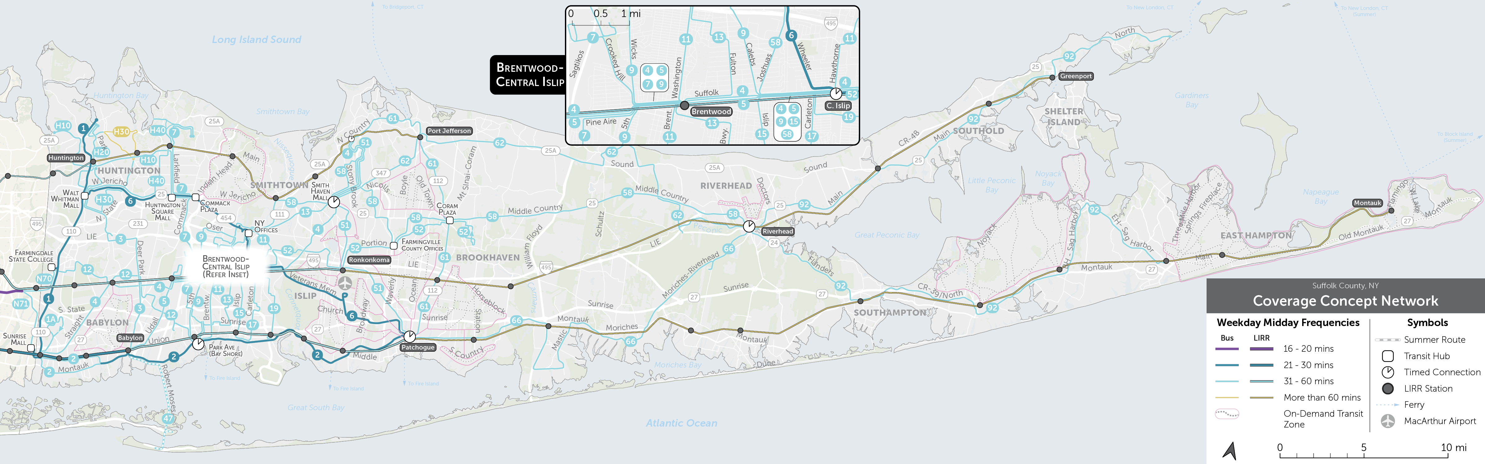
Features
- Less Frequent Service: On most routes, buses come every 60 minutes (light blue). These routes only run until 6 pm. There are three routes where buses come every 30 minutes (dark blue) until 6 pm and then every hour till 10 pm.
- Timed Connections: In places like Riverhead, Central Islip, Patchogue, Bay Shore, and Smith Haven Mall, you can make timed connections between some routes, so you won’t have to wait as long to make transfers.
- Demand Response Transit Zones: Some places can be better served by Demand Response Transit over a fixed bus route. These zones are shown as pink boundaries with dotted streets. In these zones, you can request a pickup 30-45 minutes in advance at a nearby gray, dotted street, which will connect you to a nearby hub.
Outcomes
- Overall Transit Coverage: 52,000 more people (roughly 3% of the County’s population) and 23,000 more jobs are within ½ mile of some transit service than today.
- Frequent Transit Coverage: Little change in the number of people and jobs within ½ mile of frequent transit (30-minute frequency).
- Job Access: An average resident can reach 13% more jobs within 60 minutes by walking and using transit, thanks to more direct routes and timed connections.
- Equity: Similar increases in access to jobs for people of color, low-income and car-free residents of Suffolk County.
For a more detailed description of the Coverage Concept you can read our Choices and Concepts Report.
Ridership Concept
The Ridership Concept is designed to maximize transit ridership by concentrating resources in the densest and busiest areas of the County to provide higher frequency service.
The first map shows the Ridership Concept network in the entire County, while the second map focuses on the Western part. You can click on the maps to open them in a new tab to view them in more detail. Lines are colored by how frequently buses arrive on them during the middle of the day on weekdays:
- On a dark blue line, buses come every 30 minutes
- On a light blue line, buses come every 60 minutes
- On a tan line, buses come less frequently than every 60 minutes
- Inside a pink zone, you can request a pickup (with a 30-45 minute wait) at a nearby gray-dotted street to connect to nearby routes
Note that this is not a proposal, but a concept. We want to know your preference.
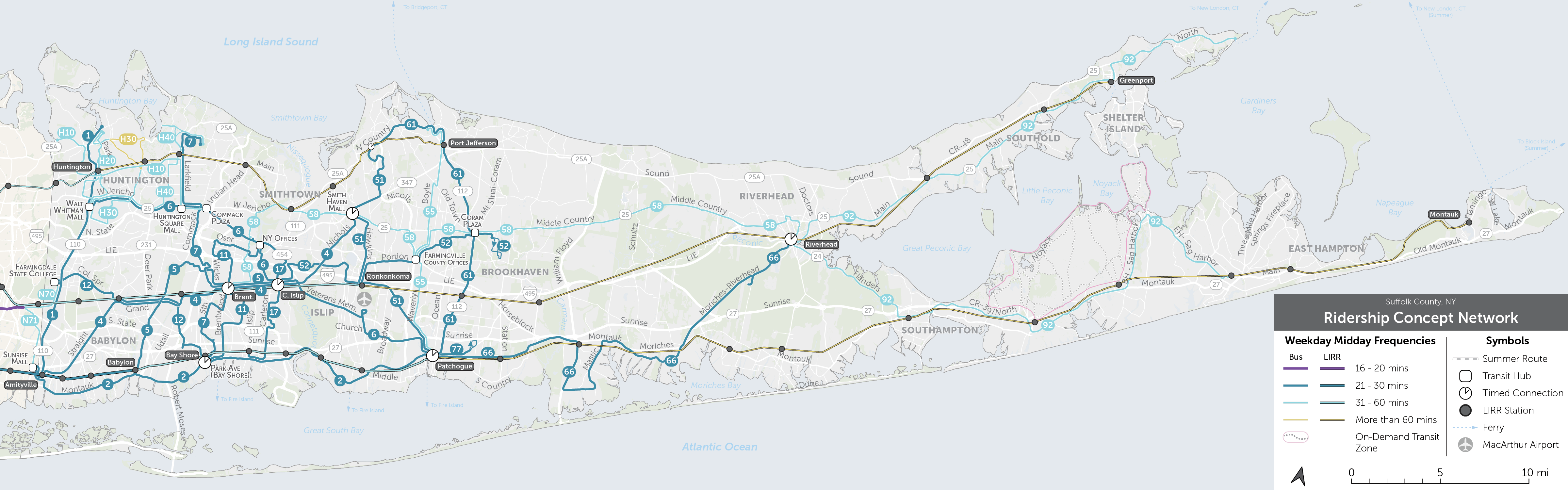
Features
- More Frequent Service: On most routes (dark blue), buses come every 30 minutes until 6pm and then every hour until 10pm.
- Concentrated Service: Service is concentrated into fewer and more frequent corridors. Some areas near infrequent transit today are not included in the Ridership Concept.
- Timed Connections: In places like Riverhead, Central Islip, Brentwood, Patchogue, Bay Shore, and Smith Haven Mall, you can make timed connections between some routes, so you won’t have to wait as long to make transfers
Outcomes
- Frequent Transit Coverage: 472,000 more people (32% of the County’s population) and 190,000 more jobs are within ½ mile of a stop with 30-minute bus service.
- Overall Transit Coverage: 238,000 fewer people (16% of the County’s population) and 77,000 fewer jobs will be within ½ mile of any transit service overall.
- Job Access: This Concept concentrates transit service to make it most useful in areas where most people live and work. Many more corridors have 30-minute service instead of 60-minute service. Hence, the number of jobs people can access within 60 minutes by transit increases dramatically: 49% more for an average resident.
- Equity: Low-income residents can reach 57% more jobs, car-free residents can reach 53% more jobs, and people of color can reach 63% more jobs on average within 60 minutes.
For a more detailed description of the Ridership Concept you can read our Choices and Concepts Report.
Existing Network
The two maps here are of the existing bus network in Suffolk County. The first map shows the network across the entire County, while the second map zooms in on the Western part to show more detail.
Lines are colored by how frequently buses arrive on them during the middle of the day on weekdays:
- On a dark blue line, buses come every 30 minutes.
- On a light blue line, buses come every 45-60 minutes.
- On a tan line, buses come less frequently than every 60 minutes apart.
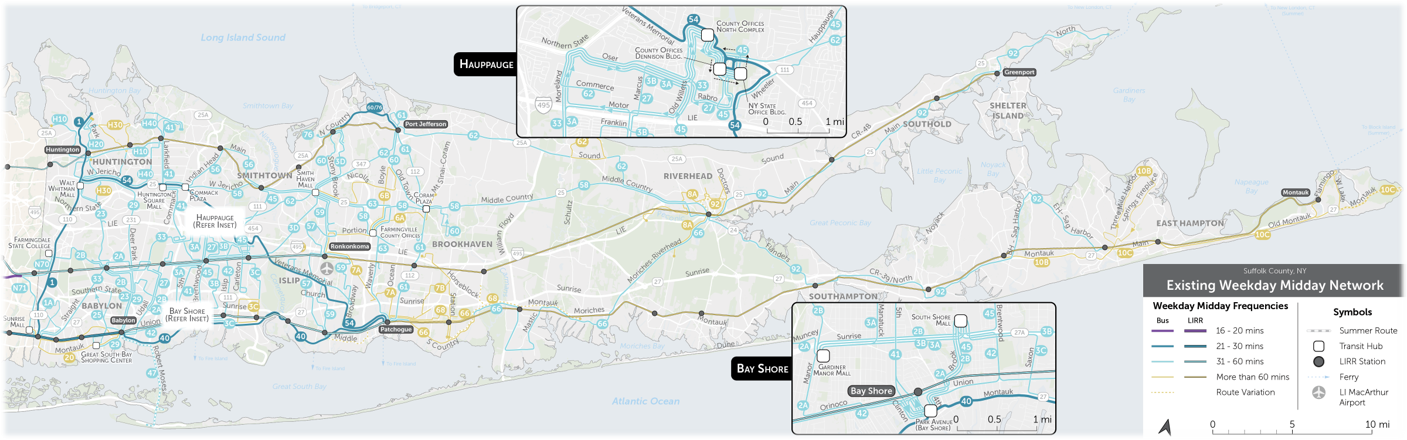
People are more likely to use frequent service (dark blue lines) because a bus is usually coming soon. They also run for longer on nights and weekends, which makes it easier for people to use the bus for all sorts of activities. Currently, only three routes: S1, S40, and S54 offer frequent service during the middle of the day.
Frequent routes need more resources to run, and within a limited budget, it is not possible to run frequent routes everywhere. Because the County is so large, its resources are spread thin. Most SCT routes are hourly or less frequent, shown in light blue or tan.
For a more detailed description of the Existing Network you can read our Choices and Concepts Report.


